Land Diversity: Can the Past be Prologue?
From farmer surveys and focus groups to deep dive futuring and AI-driven imagery, the Diverse Corn Belt Team has examined the prospects for improving rural landscape diversity in the Midwest from virtually every angle.
Many of these initiatives have focused on current trends and challenges to identify ways to bridge the gap between today’s reality and a more diversified future. But a recently completed two-year project found hopeful solutions by looking deep into a rural landscape’s past.
Cheyenne Lei, a postdoctoral researcher in the School of Earth, Environment, and Sustainability at the University of Iowa, spent two years working with Dr. Silvia Secchi and the Diverse Corn Belt’s Modeling Team on a project that examined the evolution of the rural landscape in one Iowa county over more than a century.
The goal is to gain an understanding of what land areas were used for specific purposes, and why there was such a substantial movement towards more landscape consolidation and simplification over the past 50 years. The results will serve to inform farmers that want to return to a more diversified farm operation but aren’t sure where to start.
“From 725 farmers who responded to DCB surveys, we received a lot of information about what they are most interested in seeing happen on the landscape as far as diversification,” Lei says. “Our job through the work of all the Modeling and Education Teams is to help form the connection between where we are now and where we could be.”
The surveys pointed to farmer interest in alternative crops that hearken to the past in rural Iowa, Illinois, and Indiana.
“A lot of respondents were interested in wheat and oats,” Lei says, “and we’ve seen that they have been planted on the landscape previously and historically.” .
An agricultural ecologist and expert on GIS and remote sensing, Lei spent a decade in Michigan working on agricultural landscapes prior to arriving in Iowa. Her work looked at the farmer decision making processes, from crop choices and rotations to agronomic management, fertilization, and irrigation.
She also examined the impact of government policies such as the Conservation Reserve Program, and how it blends with conventional landscapes to create a picture of corn production. and how cover crops would fit.

“From this data we can tease out where the really good agricultural lands are, because we don’t want to harm the farmer’s bottom line.”
Surprisingly Diverse
Lei’s Iowa project focused on the north-central county of Winnebago on the Minnesota state line, which offered a relative wealth of historical land use data from a variety of sources.
“It’s been really well documented over the last 100 to 125 years,” Lei says. “We’ve been able to reconstruct and digitize what the landscape had looked like for a really large portion of Winnebago county.”
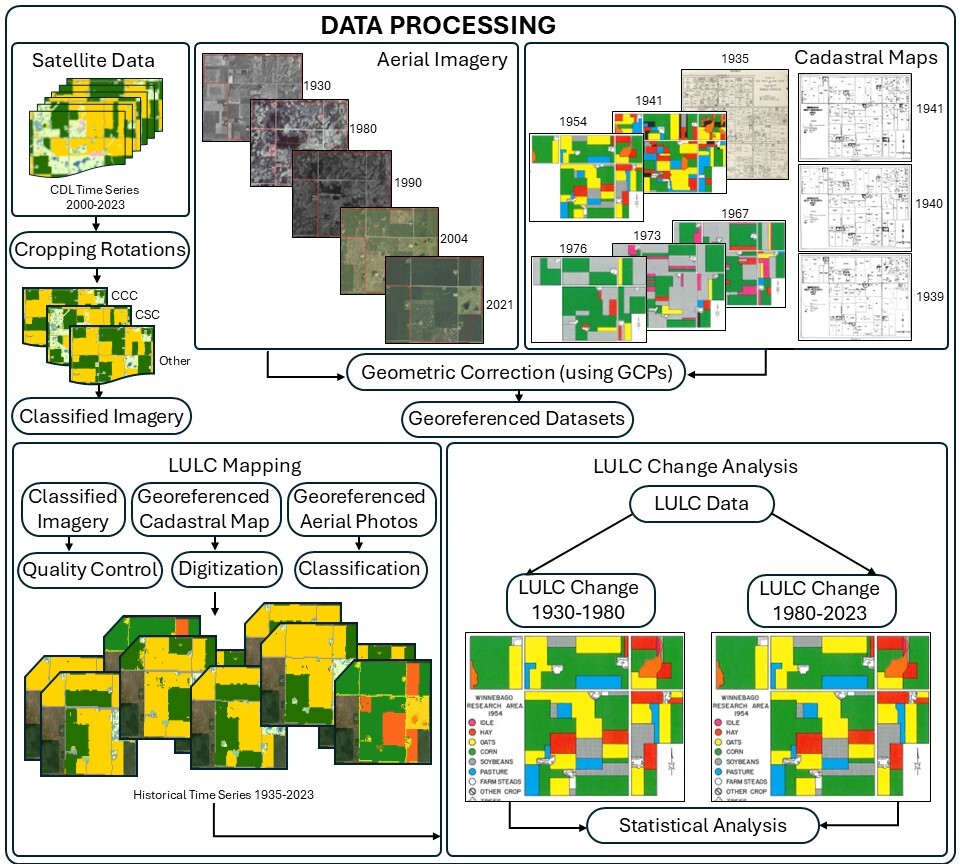
Lei dug into Integrated Public Use Microdata Series (IPUMS), the world’s largest collection of publicly available individual-level census data, and was able to combine with land surveys, aerial and remotely sensed imagery, determine what farmers planted in the past, and how much of the yields they were getting, how productive it was, and how sustainable it was. While the data was temporally sporadic, it provided interesting insight.
Winnebago County in the 19th and early 20th centuries was, from an agriculture standpoint, not optimal.
“There was a lot of standing water and lakes that made it less than ideal, but sometime around 1910, you see it getting used for a number of diverse crops,” Lei says.
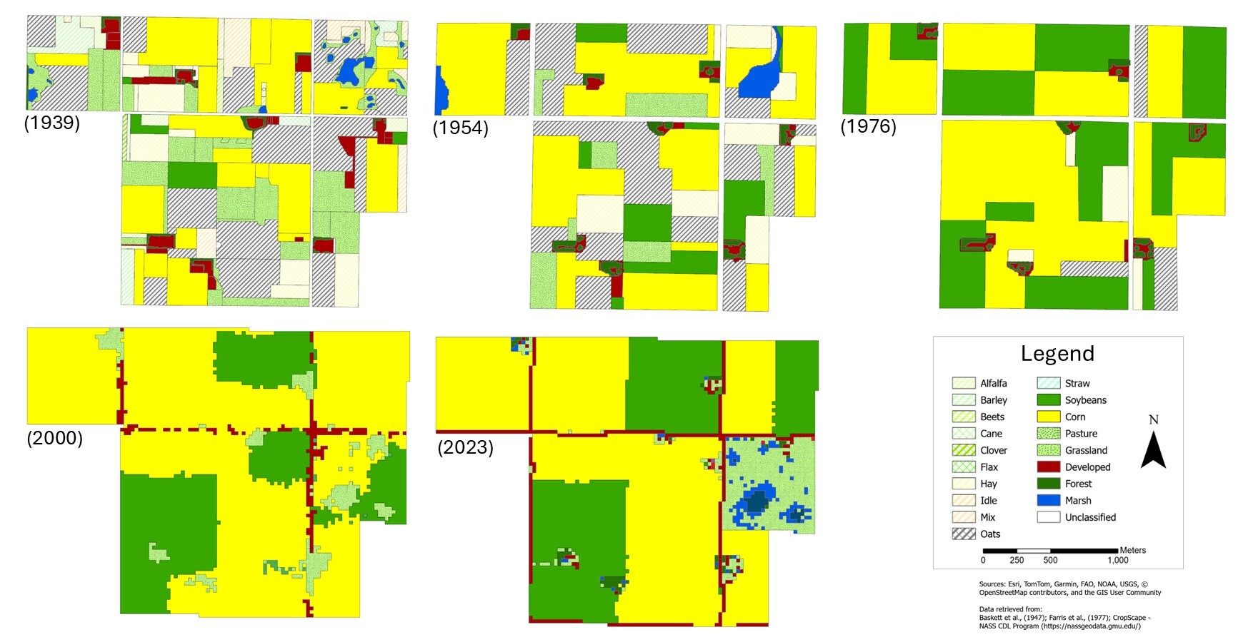
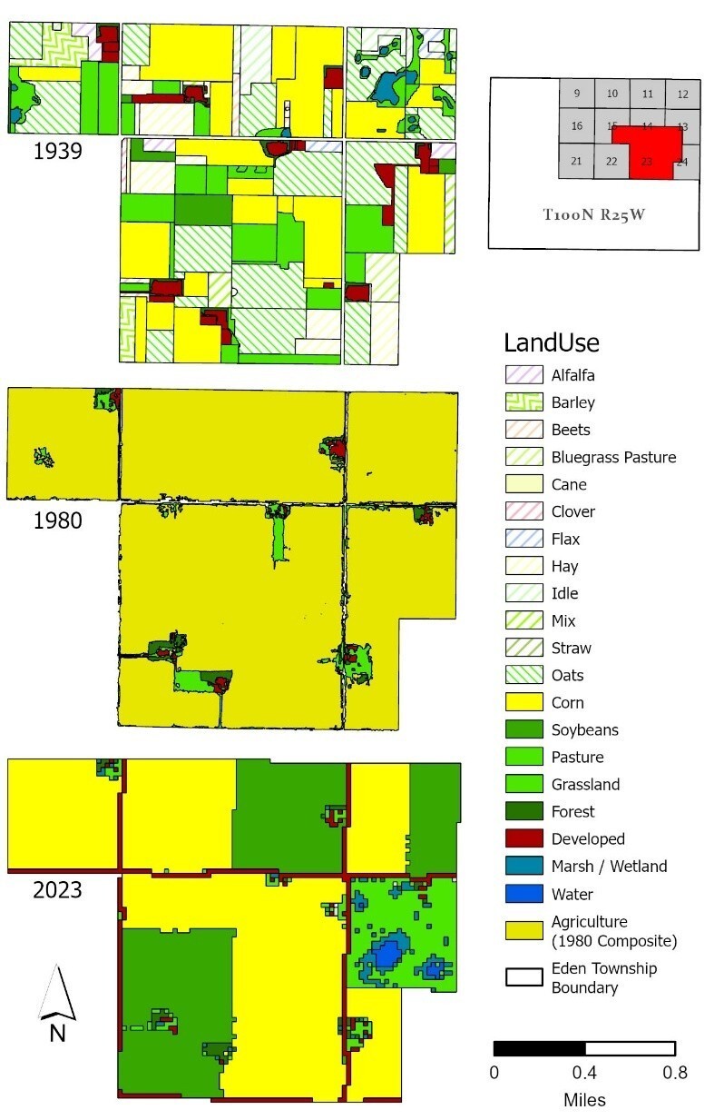
When analyzing both IPUMS and cadastral maps, Lei and her team observed nearly 60 other species on the landscape which could be combined across 26 broad land cover classes (i.e., grasses, oats, hay, horticultural crops), along with your typical corn, soybean, and livestock. (See the legend on Image 3 for a list of species discovered on one farm)
“There was actually a remarkably diverse rural landscape in Winnebago County back in the 1930s and 1940s, where instead of corn and soybean being the most dominant landscapes, it was actually hay, oats, and other crops that mainly supported livestock back in that time,” Lei says.
Before the 1920s, much of the landscape had started to be drained independently to meet the demands for agriculture, and allow for the expansion of crops. It wasn’t until the 1960s and 1970s that the intensity of subsurface drainage became more prevalent due to technological improvements, with water drained from the rural landscape to make way for the incoming corn and soybean revolution, and in short order, crop diversity shrunk to just five land cover classes: Developed, Forest, Corn, Soybean and Grassland/Pasture.
Within this most recent 50-year window (after 1976), Lei and her team combed through a wide range of data including Iowa survey imagery, historical surveys and papers, and aerial photographs to supplement existing landscape data including remote sensing and modern imagery.
“From this data we can tease out where the really good agricultural lands are, because we don’t want to harm the farmer’s bottom line,” Lei says.
In more marginal cropping areas, the deeper historical data is useful for revealing what the landscape was used for, and what could potentially be reintroduced.
Spreading the Learnings
This phase of the history project will culminate with the submission of a paper in late June, which demonstrates the process of combining historical rural landscape data from the early and mid-20th century with modern remote imagery and photography to reveal spatial and temporal changes over the last 100 years.
“They come from families that have been farming for generations and want to look at the data and understand how the farm has changed over the course of years.”
From an education standpoint, the historical work is already making an impact with students from Illinois, Indiana, and Iowa who have been exposed to it while attending her class.
“Many students are part of farming families, and I’ve had students come up to me when I am teaching in the classrooms ask about it,” Lei says. “They come from families that have been farming for generations and want to look at the data and understand how the farm has changed over the course of years.”
Lei also anticipates discussing historic land use in Winnebago County with farmers as they consider diversification.
“Overall, we are making a lot of inferences based on the limited data that we have, but we also recognize that limited data is still better than no data,” Lei says.
For example, while a farmers’ exact locations are not likely to be available in detail, Lei could look at a crop or practice in a similar location and give farmers an idea of how that crop or practice could apply to their operations.
For the past decade, there has been positive progress in the county toward reintroducing grasses, pastures, and livestock into the landscape, Lei says.
“We have one hog farm that we have been observing closely that was recently reintroduced into the landscape, as well as a protected reservation area for the reintroduction of more natural grasses and pastures,” Lei says. “Between these examples and the research, we want to show how diversity can work, how we can add oats and horticultural crops and agroforestry to rural landscapes and still be sustainable in many different places.”
Next Steps
In the near-term Lei is planning to expand the project, targeting Ringgold County in the south and Washington County in the east to create a more generalized gradient of Iowa’s agricultural landscape as a whole.
“We want to recreate this same type of model and reintroduction of these potential crops and livestock using the same ancillary data that we used for Winnebago County,” she says.
Overall, a key goal is to create additional depth to the work by looking at soils and IPUMS data to understand the yields of the different types of crops, the sustainability of planting those crops, and what those yields would look like.
The goal is to create a generalized model that can work anywhere in the Midwest.
“We’re hoping that if we collect some basic information about the landscape – what is the slope, what were yields from past years, what were the crops from past years, what is the drainage like – we can at least provide a generalized model that could be used throughout the entirety of the Midwest,” says Lei. “That is very, very far down the road, but it is something that we are potentially working toward.”
This article was written by veteran agriculture journalist Paul Schrimpf, president of Alameda Communications, and edited by DCB Communications Team Member Elise Koning, project director for Conservation Technology Information Center.